Category Archives: Greenpoint Landuse and Building
Greenpoint Mapping
Hello everyone, Here is the illustrator file containing land use and zoning layers. If you have more data or info to add, make a new layer and re-upload here? That way we can form a library of data on the
Greenpoint Mapping
Hello everyone, Here is the illustrator file containing land use and zoning layers. If you have more data or info to add, make a new layer and re-upload here? That way we can form a library of data on the
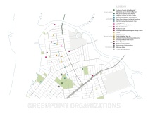
Community Organization and Land Use
Views on the Lutheran Church of Messiah: When I went to clean up Church balcony (along with Walden, Ryann and Chisun), I realized that the space was so dirty, dark and uninviting. The large windows had missing pieces of glass
Community Organization and Land Use
Views on the Lutheran Church of Messiah: When I went to clean up Church balcony (along with Walden, Ryann and Chisun), I realized that the space was so dirty, dark and uninviting. The large windows had missing pieces of glass
Land Use & Zoning
I am mostly interested in looking at zoning effectiveness and land use in both sites — but in Tacloban in particular. I found several interesting things this week as I looked deeper into both sites: For Tachloban, I had
Land Use & Zoning
I am mostly interested in looking at zoning effectiveness and land use in both sites — but in Tacloban in particular. I found several interesting things this week as I looked deeper into both sites: For Tachloban, I had

Mapping Commercial Semi-Public Spaces and Services
Based on searches on Google Maps and the Department of City Planning’s 2013 neighborhood profile for Brooklyn’s District 1 (which includes Williamsburg and Greenpoint) I have started to put together some preliminary maps which pinpoint the locations of particular types
Greenpoint: Active & Visible
I am interested in exploring alternative services and organizations that the spaces at Lutheran Church of the Messiah can provide and host in order to activate the church and make it more visible to the community. I think this exploration
Greenpoint: Active & Visible
I am interested in exploring alternative services and organizations that the spaces at Lutheran Church of the Messiah can provide and host in order to activate the church and make it more visible to the community. I think this exploration

The Accidental Playground: Brooklyn Waterfront Narratives of the Undesigned and Unplanned
Here is a link to the google book. I thought this might be relevant to our research since it deals with access to and use of the waterfront around Williamsburg and Greenpoint Summary from NYPL.org “With its detail, depth, compassion

Greenpoint Land Use
Using the resources at BYTES of the Big Apple, I put together some land use maps of Greenpoint. I would like to study adjacencies between types of land use either through audio recording or other sorts of sensory exploration. Currently,
Greenpoint Land Use
Using the resources at BYTES of the Big Apple, I put together some land use maps of Greenpoint. I would like to study adjacencies between types of land use either through audio recording or other sorts of sensory exploration. Currently,
